| AGNES station FALE | ||||||

|
|
GNSS receiver: | LEICA GR50 | |||
| GNSS antenna: | TRM59800.00 NONE | |||||
| Antenna height: | 0.000 m | |||||
| Phase center L1: | 0.090 m | |||||
| Phase center L2: | 0.117 m | |||||
| PCV antenna model: | Absolute PCV antenna model (ATX format) | |||||
|
Reference coordinates: |

|
|||||
| CHTRF/ETRF93: | ||||||
| X = 4317835.709 | φ = 46° 48' 16.161988" | |||||
| Y = 701679.765 | λ = 9° 13' 49.054791" | |||||
| Z = 4627894.605 | h = 1344.181 | |||||
| LV95 (CH1903+): | ||||||
| E = 2736752.180 | ||||||
| N = 1185264.161 | ||||||
| h = 1295.959 (Bessel) |
Receiver+antenna valid since: 03.10.2024
Information update: 26.07.2026
|
|||||

|
Sitelog in IGS/EUREF format. |

|
Documentation of changes at the stations. |

|
Compilation of important quality characteristics. |

|
Time series of coordinates (daily solutions). |
|
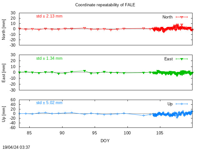
Monitoring of coordinates (last days). |

|
Monitoring of coordinates (last hours) |

|
Monitoring of the troposphere parmeters (last hours). |
Location of station FALE:
Map 1:25 000
map.admin.ch: web-zoom , Control Point Viewer
Other Geodata Portals