| AGNES station HOHT | ||||||
|
|
GNSS receiver: | LEICA GR50 | |||
| GNSS antenna: | TRM33429.20+GP NONE | |||||
| Antenna height: | 0.000 m | |||||
| Phase center L1: | 0.073 m | |||||
| Phase center L2: | 0.067 m | |||||
| PCV antenna model: | Absolute PCV antenna model (ATX format) | |||||
|
Reference coordinates: |

|
|||||
| CHTRF/ETRF93: | ||||||
| X = 4372948.882 | φ = 46° 19' 9.860847" | |||||
| Y = 596119.644 | λ = 7° 45' 45.726668" | |||||
| Z = 4590551.850 | h = 985.769 | |||||
| LV95 (CH1903+): | ||||||
| E = 2624959.431 | ||||||
| N = 1129829.729 | ||||||
| h = 934.862 (Bessel) |
Receiver+antenna valid since: 15.11.2024
Information update: 26.07.2026
|
|||||

|
Sitelog in IGS/EUREF format. |

|
Documentation of changes at the stations. |

|
Compilation of important quality characteristics. |

|
Time series of coordinates (daily solutions). |

|
Monitoring of coordinates (last days). |

|
Monitoring of coordinates (last hours) |

|
Monitoring of the troposphere parmeters (last hours). |
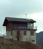
Location of station HOHT:
Map 1:25 000
map.admin.ch: web-zoom , Control Point Viewer
Other Geodata Portals